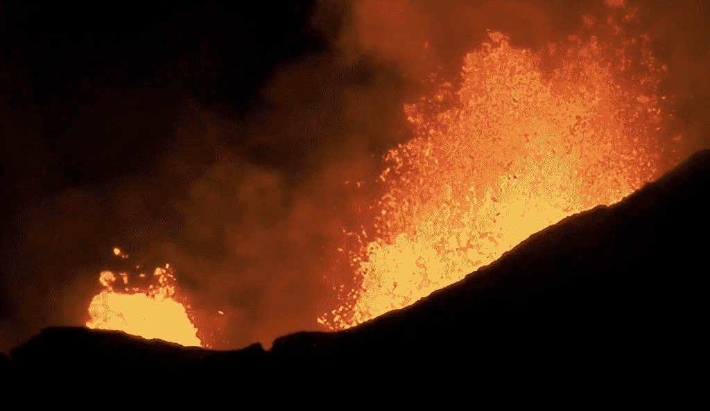
Your news and social media timelines might be flooded with images of the vigorous volcanic eruptions in Hawaii. These jaw-dropping scenes with fountains and rivers of lava are absolutely amazing.
Those scenes along with potential misunderstanding have led to some people canceling Hawaii vacations. Per this Pacific Business News article, Hawaiian Airlines reports a decline in sales. The executive director of the Island of Hawaii Visitors Bureau estimates anywhere from 20 to 50 percent less hotel bookings compared to last year.
Personally, we wouldn’t hesitate to go to any of the Hawaiian Islands as it is quite safe to visit. So, let’s try to clear up confusion.
Travel is safe to the Hawaiian Islands.
Hawaii Governor David Ige issued a recent statement regarding the eruption and safety of visiting Hawaii. The governor stated, “We have a skilled contingent of scientists, geologists, meteorologists, and health experts whose work is being supported around the clock by emergency officials and law enforcement personnel from federal, state and county agencies. They are continuously scrutinizing the activity within Kilauea volcano and providing clear, carefully though-out advice with the purpose of keeping the public safe and informed.” He goes on to say, “The experts are telling us there is no danger from the eruptions to anyone outside of the areas that have been evacuated.”
The lava eruptions are isolated to a relatively small area of Hawaii (Big) Island
There are no eruptions on the islands of Kauai, Oahu, Maui, Molokai and Lanai. The current, news-making eruptions are isolated to a residential area on the eastern tip of Hawaii (Big) Island.
We created the following image of the state of Hawaii to indicate (with the red box) the relatively small area where the lava eruption is taking place.
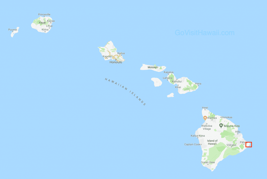 The lava eruption area is not where tourists frequently visit, though sadly, many people have lost their homes.
More about Kilauea Volcano and the current eruption area.
Kilauea is one of five volcanoes that make up the Big Island of Hawaii.
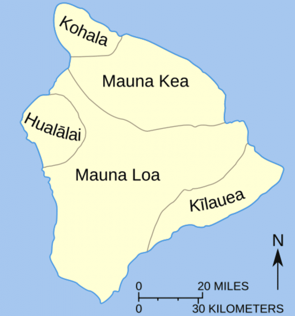
Kilauea is the most active volcano in Hawaii. It has been actively erupting since 1983.
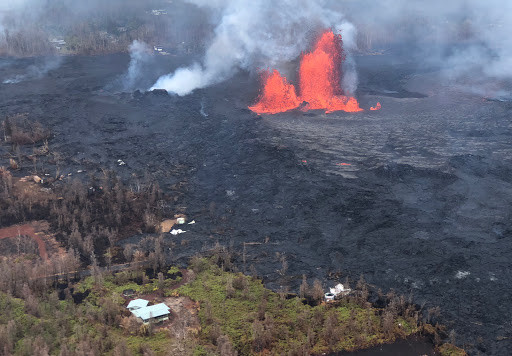
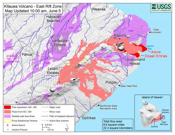
The lava activity moves from site to site. Most recently, the lava dramatically shifted from the summit area at Hawaii Volcanoes National Park to the lower East Rift Zone, which is in lower Puna. The following map shows the lower East Rift Zone with lava activity indicated.
The current eruption is many miles away from the Big Island beach resorts.
Tall mountains and many miles separate the eruption site from the western side of Hawaii (Big) Island. The western side is where all the main beach resorts are. How many miles separate the beach resorts from the eruption? For an example, we searched Google Maps for directions from Leilani Estates, where the current eruption started, to Waikoloa Beach Resort, which is a very desirable and popular Big Island beach resort. The shortest driving distance is 89 miles with a drive time of one hour and fifty minutes. (You can see that Google Map search here.)
Note that our example directions go across Saddle Road, Highway 200, which reaches an elevation of 6,632 feet. In addition to the mileage, that’s also a lot of vertical protection from the eruption.
Waikoloa Beach Resort, Mauna Lani Beach Resort, Hapuna Beach Resort, Mauna Kea Beach Resort, and Kona town are all mostly unaffected by the eruption. In fact, Mauna Lani Bay Hotel posted the following clear, calm photo on Facebook on Wednesday.
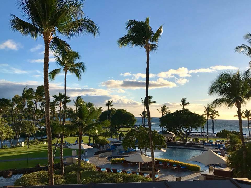
Sign me up for some of that!
Air quality is worth noting.
In the previous section, note that I said that the beach areas of the Big Island are mostly unaffected. The only affects from the current eruption that this area may experience is elevated sulfur dioxide and/or hydrogen sulfide levels as explained by this article. Air quality in the immediate vicinity of the eruptions are of most concern and hazard. This air quality monitoring site indicates air quality concerns. Just from my observations from the air quality monitoring site, on the Kona side of the Big Island, air quality levels are either safe or could have a health effect to “individuals with pre-existing medical or respiratory conditions” and is of “little or no risk to healthy individuals.”
To put the air quality issues in perspective, urban areas of southern California, are often in a moderate air quality risk per this monitoring site.
Hawaii Volcanoes National Park closed indefinitely.
While Kilauea’s lower East Rift Zone, i.e. Puna, has been vigorously erupting, the summit area has had its fair share of excitement, but not so much with lava. Earthquakes and drained lava lakes are making the news at the summit.
Pu’u O’o Crater had been Kilauea’s center for lava activity for many, many years, but the lava lake beneath Pu’u O’o drained out weeks ago.
The lava lake at Halema’uma’u Crater, which had been active for a decade, has drained. The crater continues to vent volcanic ash from subterranean activity.
Hawaii Volcanoes National Park visitor center and many of the park’s attractions are located in the summit area. Officials released an update and photos showing some of the damage from numerous earthquakes.
Can you see the lava activity?
As previously mentioned the eruptions have popped up in residential areas. Officials are only allowing residents and emergency personnel access into the area. Loiters have been cited per this Hawaii DLNR update.
Boat tours can take you to see lava flowing into the ocean and you may also be able to see some of the other lava activity. Lava Ocean Tours is one company that we know of that tours the area by boat. (Incidentally, the captain’s home was overtaken by lava just this week.)
Helicopter tours may be able to provide some distant views of the lava activity. Though, there is a temporary flight restriction around the vicinity of the eruption as described here.
We don’t know of any land tours that are specifically designed for lava viewing at the new eruption sites. Hawaii Forest & Trail has reported distant views from their Mauna Kea summit tour.
Other lava viewing opportunities may develop in coming weeks.
Useful sites for your reference
Hawaii County Civil Defense messages.
List of organizations collecting donations for people displaced by the eruption.
Hawaiian Volcano Observatory Status Report
Hawaii Lava Updates with videos from Paradise Helicopters


3 comments
Your site was most helpful in planning our trip so I am happy to chime in now. We are currently on big island, Kona side. There is absolutely no indication there is a volcano erupting. Tourism seems to be down so it may actually be a prime time to visit for less crowds. We took a drive over to Hilo as well. No indication there was a volcano! We drove all the way down to Pahoa town in order to see the volcano. As you mentioned it is closed off to visitors to get anywhere close. At night you can see the beautiful lava glow in the sky. It was incredible. We had a fabulous dinner and saw the red skies. There is a boat tour but it was $300 a person so we passed.
Thanks for the firsthand report, Kelly!
Of course! The locals are of course aware of the difference in the air/ haze. But to a first time visitor I would not have even known. We have been told that the colors are not as vibrant and things like a sunset are not as visible.