
No visit to Kauai is complete without seeing the beautiful Waimea Canyon and the Kalalau Valley. These magnificent sights are in two different Hawaii state parks that are adjacent to each other on the west side of Kauai. (For a Google Map, click here.)
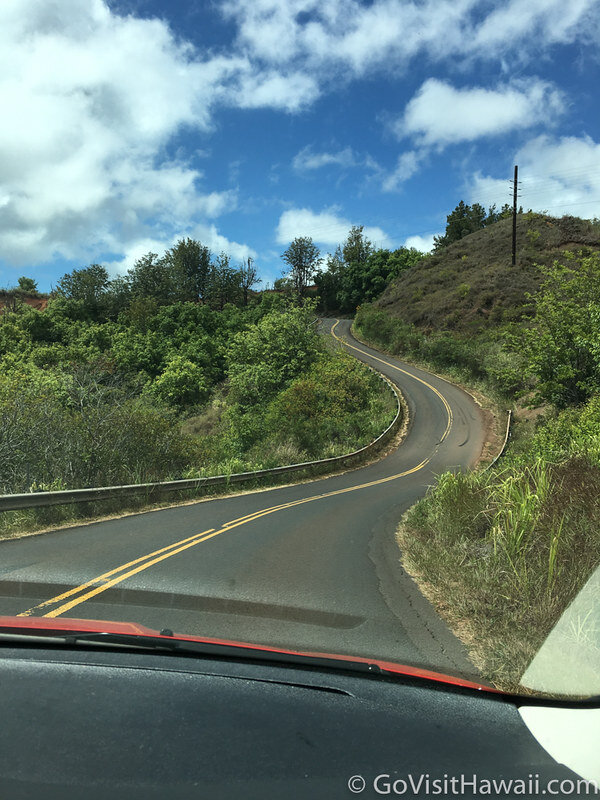
When we were planning our first trip to Kauai, I found it a little confusing that Waimea Canyon State Park and Kokee State Park are separate parks. They’re adjacent to each other and share a main road. In reality, it’s not quite as complex as it may appear as there is only one main road, HWY 550, that runs between the two.
Waimea Canyon in Waimea Canyon State Park
When you see Waimea Canyon, you might think you’ve been transported to Arizona, because Waimea Canyon has been dubbed the “Grand Canyon of the Pacific”. Waimea canyon is one mile wide by ten miles long and over 3,600 feet deep.
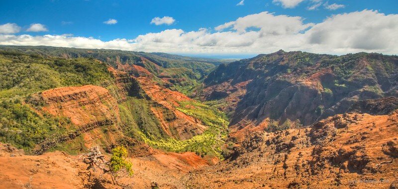
We’ve seen the Grand Canyon and Waimea Canyon. While Waimea Canyon is not nearly as big — 10 miles versus 277 miles in length and up to one-mile wide versus up to 18-miles wide — it is no less stunning. As we’ve stood at the overlooks we marvel at this landscape and can only wonder when and how this canyon came into existence.
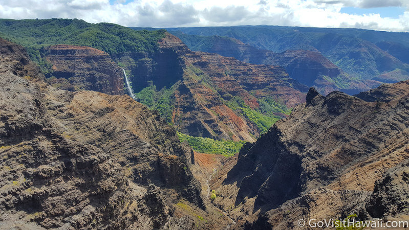
At a minimum, you must drive HWY 550 to stop off at every overlook to admire the beautiful vistas, but if you have a bit more time and energy, plan in a rewarding hike. I can recommend the Canyon Trail of Kokee State Park. It is approximately a 1.8 mile hike (one-way) into the canyon with stunning views. Allow three hours for this hike as you’ll want to pause several times to enjoy the views.
Kalalau Valley in Kokee State Park

From HWY 550 in Waimea Canyon State Park, continue driving onwards and you’ll drive into Kokee State Park. It’s a seamless transition. Continue following the highway to get to the overlooks for the stunning Kalalau Valley, an iconic Kauai view. The Kalalau Valley is actually the southern end of the Na Pali Coast State Wilderness Park.
There are two stops with views of the Kalalau Valley. The first view point is at mile marker 18 of Hwy 550. The second overlook is about a mile or so past mile marker 18 and it’s basically at the end of the paved highway. In my opinion, the second view is a bit better.
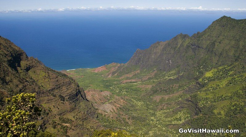
If get to the lookout and find that the valley is cloud covered, be patient for a bit and the clouds may just roll away. That happened to us and our patience was rewarded.
Tips for when you go to Waimea Canyon and Kokee state parks:
- There are two ways to get to these state parks — via Highway 550 (Waimea Canyon Drive) by Highway 552 (Kokee Road). We like taking Waimea Canyon Drive up to the parks and return on Kokee Road. The two roads will join at higher elevations to then become HWY 550 and Kokee Road. Once the roads combine the road numbering and naming system is a lit bit confusing, but with so few roads to these gorgeous views, it’s highly unlikely you’ll lose your way. Just keep driving onwards until you reach the end of the paved highway.
- A $10 parking fee per vehicle, plus a $5 entrance fee per person is required per car. Check this page for any updates to fees.
- The elevation is between 3,200 and 4,200 feet and quite a bit cooler than at the beaches, so bring a jacket or sweater. Average daytime temperatures range from as low as 45 degrees F in January to 68 degrees F in July.
- Make sure you have plenty of gas before you go, as there are no gas stations in the parks.
- Allow for at least two to three hours in this area and longer if you plan to hike.
- You can learn more about hiking trails in Kokee State Park here and Waimea Canyon here.
- Stop in at the Kokee Museum for about 30 minutes if you have the time to spare. Admission is free. See more about visiting Kokee Museum.
- There is only one restaurant in the area at Kokee Lodge, so plan accordingly.
- Be advised that you will be driving on winding roads, so take precautions if you are prone to car sickness.
- You may want to bring binoculars to enjoy closer views. Keep your eyes peeled for goats.
Have you seen Waimea Canyon and Kokee state parks?

2 comments
Many years ago my family attended a wedding at the Kokee state park. So if you love it when you visit, you can probably make arrangements to get married there also!